Waltham Abbey
Waltham Abbey is a suburban town and civil parish in the Epping Forest District of Essex, within the metropolitan and urban area of London, England, 13.5 miles (21.7 km) north-east of Charing Cross.
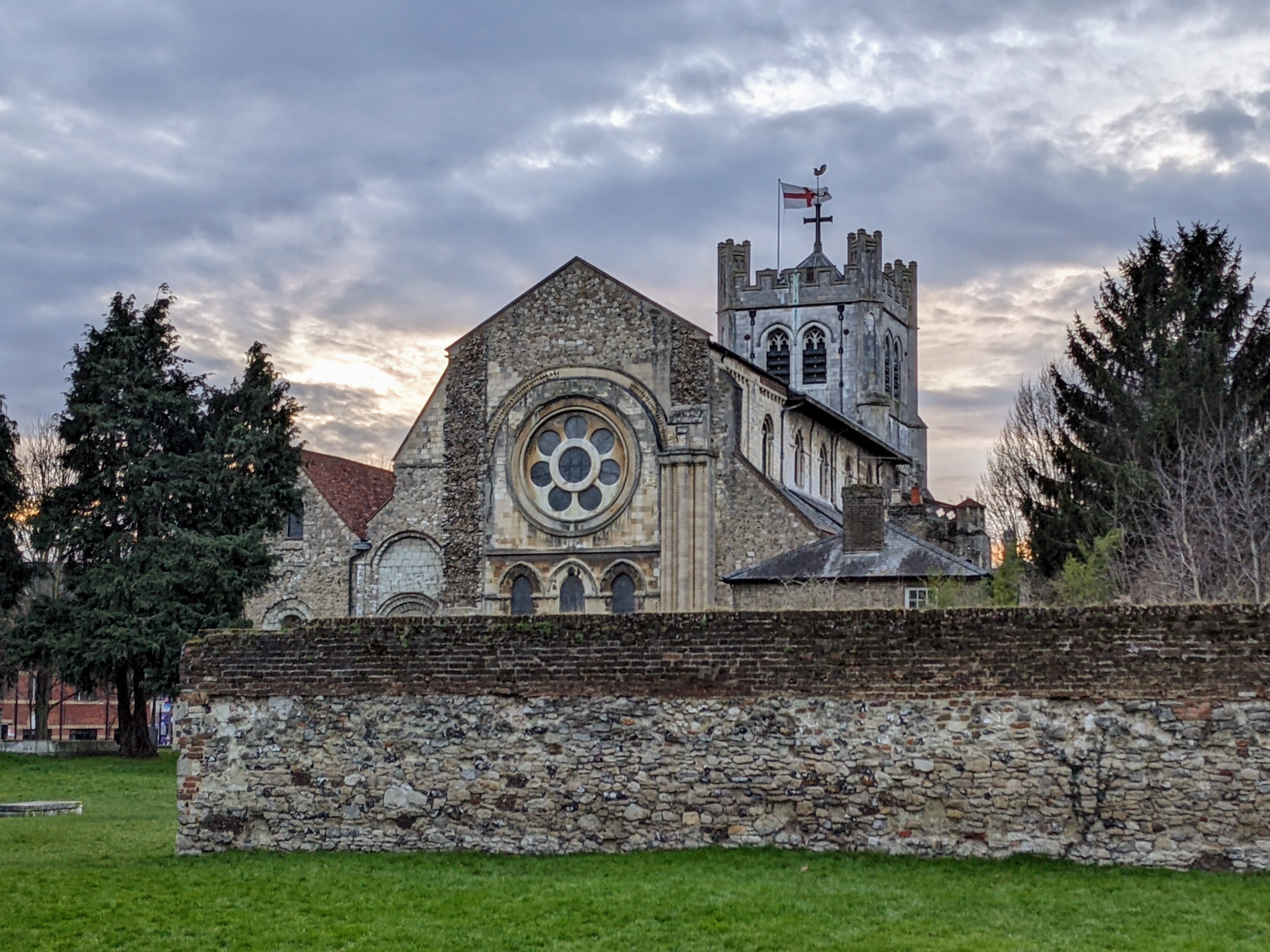
Waltham Abbey is a suburban town and civil parish in the Epping Forest District of Essex, within the metropolitan and urban area of London, England, 13.5 miles (21.7 km) north-east of Charing Cross. Situated in the Lea Valley, the town lies on the Greenwich Meridian between the River Lea in the west and Epping Forest in the east, with large sections forming part of the Metropolitan Green Belt.
Adapted from Wikipedia, CC BY-SA 4.0.
Worth seeing in and around Waltham Abbey
10 places within 25 km that the world writes about, in the order of how widely: the ones a visitor has heard of first, then the ones only a local would name.
- 01Gilwell Park
Gilwell Park is the headquarters and principal camp site of The Scout Association in the United Kingdom. It is a 109-acre site on the northeastern outskirts of London, located within Epping Forest in the Sewardstonebury area of Waltham Abbey, near the border with Chingford.
3.8 km · UK camp site and activity centre for Scouting and Guiding groups and other youth organizations · Wikipedia - 02Waltham Abbey Church
The Abbey Church of Waltham Holy Cross and St Lawrence, also known as Waltham Abbey or Waltham Abbey Church, is the parish church of the town of Waltham Abbey, Essex, England. It has been a place of worship since the 7th century.
400 m · church in Waltham Abbey, Essex, England, UK · Wikipedia - 03Lee Valley Park
Lee Valley Regional Park is a 10,000-acre 26 miles long linear park, much of it green spaces, running through the northeast of Greater London, Essex and Hertfordshire. The park follows the course of the River Lea along the Lea Valley from Ware in Hertfordshire through Essex and the north east of Greater London, through the Queen Elizabeth Olympic Park to East India Docks Basin on the River Thames.
1.8 km · park in the Lee Valley · Wikipedia - 04Theobalds House
Theobalds House, also known as Theobalds Palace, was a significant 16th-century stately home located in the parish of Cheshunt, Hertfordshire. Set in extensive parkland, it was a residence of statesmen Lord Burghley and his son the Earl of Salisbury, both leading royal advisers.
3.9 km · ruined stately home and palace near Cheshunt in Hertfordshire, England, UK · Wikipedia - 05Forty Hall
Forty Hall is a manor house of the 1620s in Forty Hill in Enfield, north London. The house, a Grade I listed building, is today used as a museum by the London Borough of Enfield.
5 km · Grade I listed historic house museum in the London Borough of Enfield, United Kingdom · Wikipedia - 06Waltham Abbey Royal Gunpowder Mills
The Royal Gunpowder Mills are a former industrial site in Waltham Abbey, England. It was one of three Royal Gunpowder Mills in the United Kingdom.
1.1 km · military museum in Essex, England, UK · Wikipedia - 07Copped Hall
Copped Hall, also known as Copt Hall or Copthall, is a mid-18th-century English country house in Epping Upland, Essex which has been undergoing restoration since 1999. Today, Copped Hall refers to the upstanding house, while Copt Hall or Copthall refer to the older Tudor and earlier houses.
4.8 km · Grade II listed historic house in Epping Upland, England · Wikipedia - 08Capel Manor College
Capel Manor College is a special environmental college located in Enfield, Greater London. The College has five campuses across the capital, Crystal Palace Park, Enfield, Gunnersbury Park, Mottingham and Regent's Park.
4.1 km · college in Enfield, UK · Wikipedia - 09King George V Reservoir
The King George V Reservoir, also known as King George's Reservoir, is located in the London Borough of Enfield and is part of the Lee Valley Reservoir Chain that supplies London with drinking water. The storage reservoir is bordered by Sewardstone and Chingford to the east and Brimsdown and Ponders End to the west, and covers 420 acres, making it the largest in London.
4 km · reservoir in the London Borough of Enfield, England, United Kingdom · Wikipedia - 10Wright's Flour Mill
Wright's Flour Mill is located in Wharf Road, Ponders End, Enfield. It is Enfield's oldest working industrial building.
5.2 km · industrial building in the Enfield borough of London, UK · Wikipedia
Ranked by the number of language editions of Wikipedia with an article on each, from Wikidata; the sentences are the openings of those articles, CC BY-SA 4.0.
What Wikivoyage says to see
- 01Epping Ongar Railway
- 02Copped Hall
CM16 5HR (access via Crown Hill, south of Epping), info@coppedhalltrust.org.uk.
- 03Hill Hall
Theydon Mount, CM16 7QQ (approximately three miles south-east of Epping, between Epping and Stapleford Tawney).
From Wikivoyage: Waltham Abbey, CC BY-SA 4.0. Not yet checked by us.
Things to do
- 01Walk
- 02North Weald Airfield
- 03The Oak Trail
- 04Epping Forest District Museum
39-41 Sun Street, Waltham Abbey, EN9 1EL (in Waltham Abbey, approximately 6 mi (9.7 km) west of Epping; access by road or bus from the town),.
From Wikivoyage: Waltham Abbey, CC BY-SA 4.0. Not yet checked by us.
Where to eat
- 01Belgique
Open for breakfast, lunch and afternoon teas.
- 02Harleys Bistro and Lounge
184 High Street, Epping, CM16 4AQ,.
- 03Garnon Bushes
13 Coopersale Common, Coopersale, CM16 7QS,.
- 04Piya Bar and Kitchen
74-76 High St, Epping, CM16 4AE, info@piyabarandkitchen.co.uk.
- 05Slice Sourdough Pizza
4 Station Road, Epping, Essex, CM13 3HU, info@slicesourdoughpizza.com.
From Wikivoyage: Waltham Abbey, CC BY-SA 4.0. Not yet checked by us.
Getting to Waltham Abbey
- Airports
- London Stansted (STN), 28 km · London Luton (LTN), 33 km · London Heathrow (LHR), 40 km
- Stations
- Turkey Street railway station, 3.5 km · Southbury railway station, 5.5 km · Cheshunt railway station, 2.6 km · Theobalds Grove railway station, 2.6 km · Chingford railway station, 5.8 km
- London → Waltham Abbey22 km · quickest by road, 1h 11m · £3.5–5
- Birmingham, West Midlands → Waltham Abbey157 km · quickest by road, 2h 42m · £17–22
- Nottingham, Leicestershire → Waltham Abbey161 km · quickest by road, 2h 57m · £18–24
- Plan a tripFrom anywhereThe planner compares every way there from wherever you are.
Road and air are today’s quick answer; timetabled trains, buses and ferries load on the results page from the operators’ feeds.
No local-transport research exists yet for Waltham Abbey
Our researched notes are written from a sourced entry: every shared taxi, boat and village bus with its operator, its rule, its fare and the year we saw it, and what could not be confirmed. Nobody has done that work for Waltham Abbey. What is above is what we hold from open sources; nothing here pretends to be more.
- Get inUse Woolwich Ferry then for destinations in south London.
From Wikivoyage: London/East, CC BY-SA. Not yet checked by us; that article was last edited 2026-09.
- 01143 km
- 02329 km
- 03381 km
- 04549 km
- 05585 km
If you know how people move in Waltham Abbey – the stand, the rule, the fare – tell us, and the note gets an entry.
Next door to Waltham Abbey
Waltham Abbey is 18 km from Islington, the nearest large city, whose note carries the wider picture.
- Cheshunttown in Hertfordshire, England3.1 km
- Waltham Crosstown in Hertfordshire, England2.3 km
- Broxbournelocal government district with borough status in Hertfordshire, England5 km
- Ponders Endcommercial and residential district of the London Borough of Enfield, London, England5.6 km
- Upshirevillage in Essex, England3.4 km
- Sewardstonevillage in Essex, England, UK2.8 km