Wādī Fūkīn
Wadi Fukin is a Palestinian village in the West Bank, eight kilometers southwest of Bethlehem in the Bethlehem Governorate.
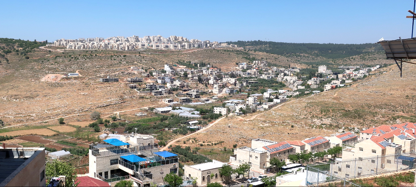
Wadi Fukin is a Palestinian village in the West Bank, eight kilometers southwest of Bethlehem in the Bethlehem Governorate. The village is located on 700 acres of land, between the Green Line and the Israeli West Bank barrier, with the Israeli settlement of Beitar Illit on one side and the Israeli town of Tzur Hadasa on the other. According to the Palestinian Central Bureau of Statistics, Wadi Fukin had a population of over 1,342 in 2017. The village relies on agriculture as its primary source of income. Israel served eviction orders on the village in September 2014.
Adapted from Wikipedia, CC BY-SA 4.0.
Worth seeing in and around Wādī Fūkīn
One place within 25 km that the world writes about, in the order of how widely: the ones a visitor has heard of first, then the ones only a local would name.
- 01Betar
Betar was an ancient Jewish town in the Judaean Mountains, continuously inhabited since the Iron Age and up until the 2nd century CE. It is most famously known as the final stronghold of the Bar Kokhba Revolt. It was besieged and destroyed by the Romans in 135 CE. Betar appears in various ancient sources, including the Jerusalem and Babylonian Talmuds, as well as in midrashic literature and Patristic writings.
4 km · last Judah's fort held in the Bar Kokhba's revolt and adjacent modern locations · Wikipedia
Ranked by the number of language editions of Wikipedia with an article on each, from Wikidata; the sentences are the openings of those articles, CC BY-SA 4.0.
Getting to Wādī Fūkīn
- Airports
- Ben Gurion (TLV), 40 km · Queen Alia (AMM), 84 km · Marka International (Amman Civil) (ADJ), 89 km
- Amman → Wādī Fūkīn84 km · quickest by road, 2h 38m · JD5–6
- El Arish → Wādī Fūkīn140 km · quickest by road, 4h 27m · E£335–445
- Eilat → Wādī Fūkīn240 km · quickest by road, 5h 34m · ₪105–140
- Plan a tripFrom anywhereThe planner compares every way there from wherever you are.
Road and air are today’s quick answer; timetabled trains, buses and ferries load on the results page from the operators’ feeds.
No local-transport research exists yet for Wādī Fūkīn
Our researched notes are written from a sourced entry: every shared taxi, boat and village bus with its operator, its rule, its fare and the year we saw it, and what could not be confirmed. Nobody has done that work for Wādī Fūkīn. What is above is what we hold from open sources; nothing here pretends to be more.
- Get inHitchhiking (described below) can be difficult if you have a suitcase.
- Get inIf you prefer to hitchhike, take the 31 or 32 local buses to the trempiada (see below).
- Get inIf you don't have a car, the fastest, cheapest and easiest travel option is hitchhiking, or in Israeli English, "to catch a tremp".
- Get inThe main hitchhiking hub is in the southern exit from Jerusalem, a place called "Tzomet HaMinharot", or informally the trempiada.
- Get inFrom here you can get another tremp to a specific settlement, although many Israelis consider it unsafe to hitchhike here (in the past, it has been the site of kidnappings and shootings by Palestinians).
From Wikivoyage: Gush Etzion, CC BY-SA. Not yet checked by us; that article was last edited 2026-07.
- 01158 km
- 02239 km
- 03361 km
- 04709 km
- 051,065 km
If you know how people move in Wādī Fūkīn – the stand, the rule, the fare – tell us, and the note gets an entry.
Next door to Wādī Fūkīn
Wādī Fūkīn is 13 km from Jerusalem, the nearest large city, whose note carries the wider picture.
- BattirPalestinian village in the West Bank3.7 km
- Beitar Illitcity in The West Bank1.5 km
- Nahalinmunicipality in Bethlehem Governorate2.7 km
- Gva'otIsraeli settlement in the West Bank3.1 km
- Husanmunicipality in Bethlehem Governorate2.9 km
- Tzur Hadassahhuman settlement in Israel1.5 km