Sea Gate, Brooklyn
Sea Gate is a private gated community at the far western end of Coney Island at the southwestern tip of the New York City borough of Brooklyn.
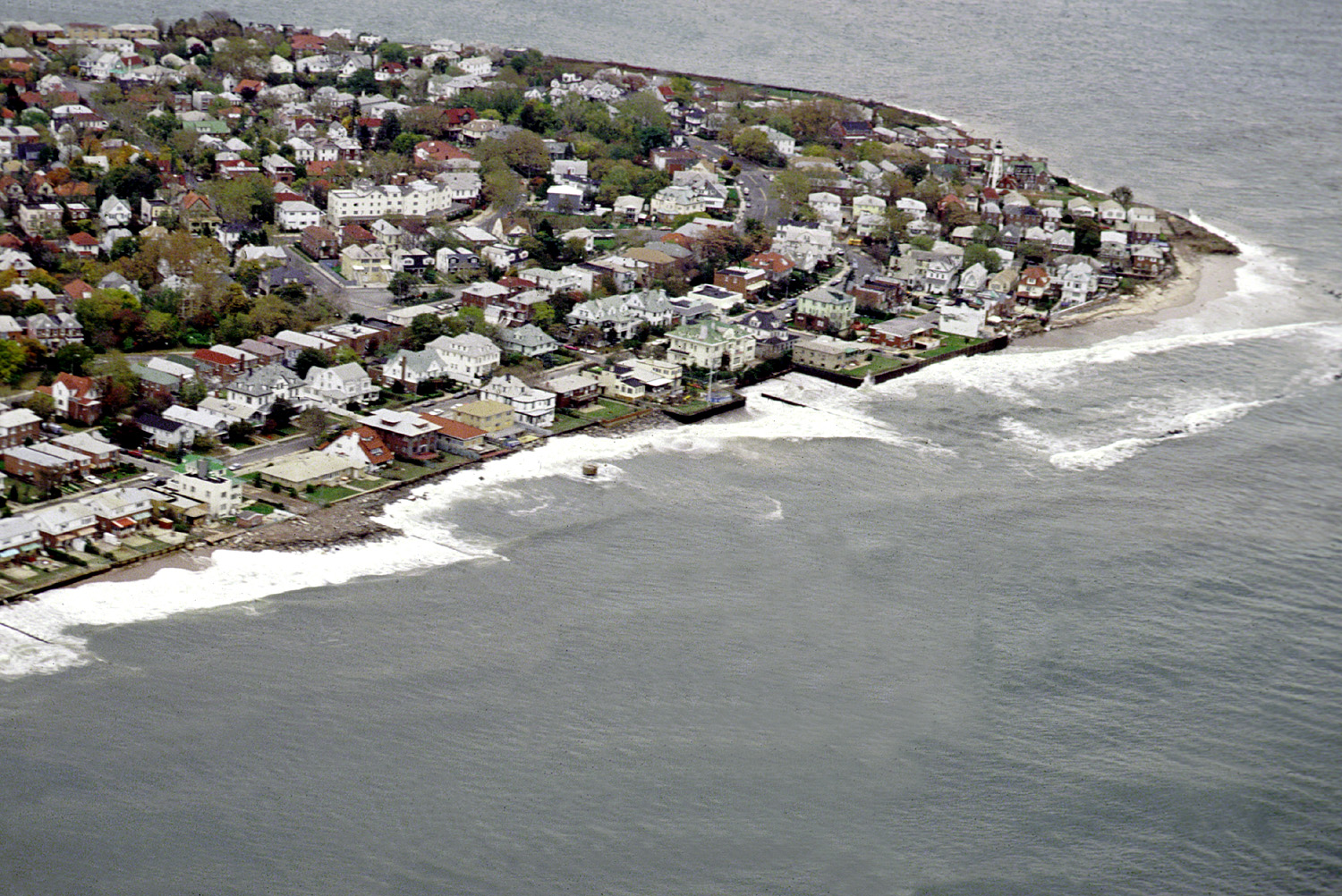
Sea Gate is a private gated community at the far western end of Coney Island at the southwestern tip of the New York City borough of Brooklyn. Located on the portion of the Coney Island peninsula west of West 37th Street, it contains mostly single-family homes, some directly on Gravesend Bay.
Adapted from Wikipedia, CC BY-SA 4.0.
Worth seeing in and around Sea Gate, Brooklyn
8 places within 25 km that the world writes about, in the order of how widely: the ones a visitor has heard of first, then the ones only a local would name.
- 01Verrazzano-Narrows Bridge
The Verrazzano–Narrows Bridge is a suspension bridge connecting the boroughs of Staten Island and Brooklyn in New York City, New York, U.S. It spans the Narrows, a body of water linking the relatively enclosed New York Harbor with Lower New York Bay and the Atlantic Ocean. It is the only fixed crossing of the Narrows.
4.5 km · bridge in New York City · Wikipedia - 02Prospect Park
Prospect Park is a 526-acre urban park in the New York City borough of Brooklyn. The park is situated between the neighborhoods of Park Slope, Prospect Heights, Crown Heights, Prospect Lefferts Gardens, Flatbush, and Windsor Terrace, and is adjacent to the Brooklyn Museum, Grand Army Plaza, and the Brooklyn Botanic Garden.
9.9 km · public park in Brooklyn, New York City · Wikipedia - 03Brooklyn College
Brooklyn College is a public university in Brooklyn in New York City, New York. It is part of the City University of New York system and enrolled nearly 14,000 students on a 35-acre campus in the Midwood and Flatbush sections of Brooklyn as of fall 2023.
7.6 km · senior college of the City University of New York, located in Brooklyn · Wikipedia - 04Lesbian Herstory Archives
The Lesbian Herstory Archives is a New York City-based archive, community center, and museum dedicated to preserving lesbian history, located in Park Slope, Brooklyn. The Archives contain the world's largest collection of materials by and about lesbians.
9.7 km · archive, history museum in Brooklyn, New York · Wikipedia - 05Todt Hill
Todt Hill is a 401-foot-tall hill formed of serpentine rock on Staten Island, New York. It is the highest natural point in the five boroughs of New York City and the highest elevation on the entire Atlantic coastal plain from Florida to Cape Cod.
9.2 km · mountain · Wikipedia - 06Luna Park
Luna Park was an amusement park that operated in the Coney Island neighborhood of Brooklyn in New York City, United States, from 1903 to 1944. The park was located on a site bounded by Surf Avenue to the south, West 8th Street to the east, Neptune Avenue to the north, and West 12th Street to the west.
2.5 km · 1903 Coney Island amusement park · Wikipedia - 07Staten Island Museum
Staten Island Museum is Staten Island’s oldest cultural institution, and the only remaining general interest museum in New York City. Founded in 1881 by fourteen of New York City’s first “environmental activists”, the Staten Island Museum houses artifacts and specimens from ancient to contemporary periods.
9.5 km · museum in Staten Island, New York · Wikipedia - 08Gowanus Canal
The Gowanus Canal is a 1.8-mile-long canal in the New York City borough of Brooklyn, on the westernmost portion of Long Island. Once a vital cargo transportation hub, the canal has seen decreasing use since the mid-20th century as domestic shipping declined.
10 km · canal in Brooklyn, New York City · Wikipedia
Ranked by the number of language editions of Wikipedia with an article on each, from Wikidata; the sentences are the openings of those articles, CC BY-SA 4.0.
Getting to Sea Gate, Brooklyn
- Airports
- Newark Liberty (EWR), 19 km · John F. Kennedy (JFK), 21 km · LaGuardia (LGA), 25 km
- Stations
- 25th Avenue, 2.9 km · 86th Street, 5.3 km · Coney Island-Stilwell Avenue, 2.3 km · Bay 50th Street, 2.4 km · 20th Avenue, 3.2 km
- Philadelphia → Sea Gate, Brooklyn120 km · quickest by road, 2h 36m · $12–17
- Hartford → Sea Gate, Brooklyn172 km · quickest by road, 3h 41m · $16–22
- Albany → Sea Gate, Brooklyn232 km · quickest by road, 4h 22m · $21–29
- Plan a tripFrom anywhereThe planner compares every way there from wherever you are.
Road and air are today’s quick answer; timetabled trains, buses and ferries load on the results page from the operators’ feeds.
No local-transport research exists yet for Sea Gate, Brooklyn
Our researched notes are written from a sourced entry: every shared taxi, boat and village bus with its operator, its rule, its fare and the year we saw it, and what could not be confirmed. Nobody has done that work for Sea Gate, Brooklyn. What is above is what we hold from open sources; nothing here pretends to be more.
- Get inThe [http://www.nywatertaxi.com Water Taxi, at Fulton Ferry Landing, provides service from various points in Manhattan along the East River.
- Get inThe Water Taxi has service between southern Manhattan and Red Hook, often used by customers of the Red Hook Ikea.
From Wikivoyage: Brooklyn, CC BY-SA. Not yet checked by us; that article was last edited 2026-09.
- 0173 km
- 02574 km
- 032,621 km
- 042,627 km
- 052,752 km
If you know how people move in Sea Gate, Brooklyn – the stand, the rule, the fare – tell us, and the note gets an entry.
Next door to Sea Gate, Brooklyn
Sea Gate, Brooklyn is 9 km from Brooklyn, the nearest large city, whose note carries the wider picture.
- Brooklynborough of New York City, New York, United States9.6 km
- Coney Islandcoastal neighborhood in Brooklyn, New York City, New York, USA2.2 km
- Brighton Beachneighborhood of Brooklyn in New York City, United States3.9 km
- The Narrowsstrait in New York City, USA5.3 km
- Bensonhurstneighborhood of Brooklyn in New York City, United States3 km
- Flatbushneighborhood in Brooklyn, New York City, New York, United States8 km