Padfield
Padfield is a small village near Hadfield in High Peak, Derbyshire, England.
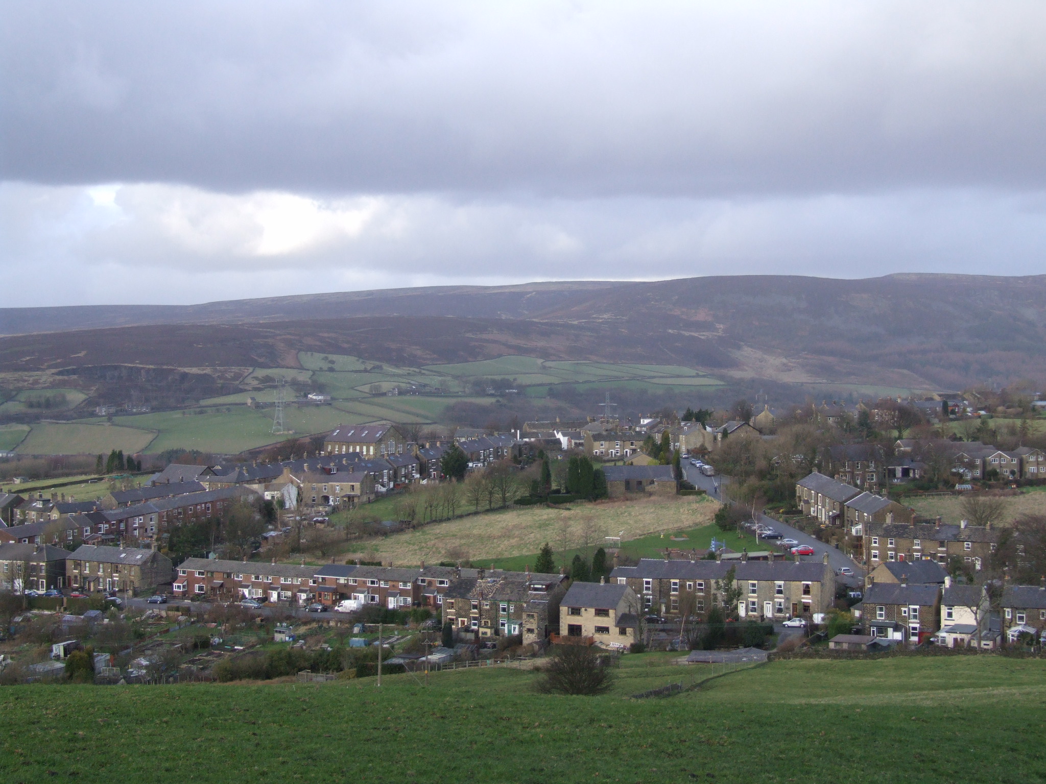
Padfield is a small village near Hadfield in High Peak, Derbyshire, England. The village is on the west side of the Peak District National Park, and the nearest town is Glossop, where many local amenities and services are based. It is in a conservation area. The population as of the 2011 census was 2,796.
Adapted from Wikipedia, CC BY-SA 4.0.
Worth seeing in and around Padfield
10 places within 25 km that the world writes about, in the order of how widely: the ones a visitor has heard of first, then the ones only a local would name.
- 01Ardotalia
Ardotalia, also known as Melandra or Melandra Castle, is a Roman fort in Gamesley, near Glossop in Derbyshire, England. Ardotalia was constructed by Cohors Primae Frisiavonum—The First Cohort of Frisiavones.
2.4 km · Roman fort in Gamesley, near Glossop in Derbyshire, England, UK · Wikipedia - 02Mouselow Castle
Glossop Castle is a Norman earthwork north of Glossop, off Hilltop Road, 14 miles east of Manchester, on the A57. The site is visible from the main road, standing atop a commanding ridge.
600 m · ringwork castle near Glossop, Derbyshire, England, UK · Wikipedia - 03Bottoms Reservoir
Bottoms Reservoir is a man-made lake in Longdendale in north Derbyshire, England. It was constructed between 1865 and 1877, by John Frederick Bateman as part of the Longdendale Chain of reservoirs to supply water from the River Etherow to the urban areas of Greater Manchester.
1 km · reservoir in Derbyshire, England, UK · Wikipedia - 04Rhodeswood Reservoir
Rhodeswood Reservoir is a man-made lake in Longdendale in north Derbyshire, England. It was constructed by John Frederick Bateman between 1849 and June 1855 as part of the Longdendale Chain of reservoirs to supply water from the River Etherow to the urban areas of Greater Manchester.
2.8 km · reservoir in Derbyshire, England, UK · Wikipedia - 05Valehouse Reservoir
Valehouse Reservoir is a man-made lake in Longdendale in north Derbyshire, England. It was built between 1865 and 1869 as part of the Longdendale Chain of reservoirs, which was built to supply water from the River Etherow to the urban areas of Greater Manchester, while maintaining a constant flow into the river.
1.8 km · reservoir in Derbyshire, England, UK · Wikipedia - 06St James' Church, Glossop
St. James's Church is an Anglican church in the evangelical tradition in the town of Glossop, Derbyshire, in the north-west of England.
2.5 km · Grade II listed church in Glossop, Derbyshire, England, UK · Wikipedia - 07Arnfield Reservoir
Arnfield Reservoir is a man-made lake in Longdendale in north Derbyshire, England. It was constructed in 1854 as part of the Longdendale chain to supply water from the River Etherow to the urban areas of Greater Manchester.
2.2 km · reservoir in Derbyshire, England, UK · Wikipedia - 08St Michael and All Angels Church, Mottram
St Michael and All Angels Church stands on Warhill overlooking the village of Mottram in Longdendale, Greater Manchester, England. The church is recorded in the National Heritage List for England as a designated Grade II* listed building.
3.7 km · church in Mottram in Longdendale, Greater Manchester, England, UK · Wikipedia - 09Church of All Saints
All Saints’ Church, Glossop, is a Grade II listed parish church in the Church of England in Glossop, Derbyshire, England.
1.6 km · Grade II listed church building in Old Glossop, High Peak, Derbyshire, England, UK · Wikipedia - 10Manor Park, Glossop
Manor Park is a city park in Glossop, Derbyshire, England.
1.8 km · English public park · Wikipedia
Ranked by the number of language editions of Wikipedia with an article on each, from Wikidata; the sentences are the openings of those articles, CC BY-SA 4.0.
Getting to Padfield
- Airports
- Manchester (MAN), 25 km · Leeds Bradford (LBA), 49 km · Liverpool John Lennon (LPL), 61 km
- Stations
- Hadfield railway station, 700 m · Glossop railway station, 1.9 km · Dinting railway station, 1.7 km
- Leeds, West Yorkshire → Padfield46 km · quickest by road, 1h 29m · £5–7
- Liverpool → Padfield68 km · quickest by road, 1h 38m · £8–10
- Nottingham, Leicestershire → Padfield78 km · quickest by road, 2h 16m · £9–12
- Plan a tripFrom anywhereThe planner compares every way there from wherever you are.
Road and air are today’s quick answer; timetabled trains, buses and ferries load on the results page from the operators’ feeds.
No local-transport research exists yet for Padfield
Our researched notes are written from a sourced entry: every shared taxi, boat and village bus with its operator, its rule, its fare and the year we saw it, and what could not be confirmed. Nobody has done that work for Padfield. What is above is what we hold from open sources; nothing here pretends to be more.
- 01312 km
- 02312 km
- 03314 km
- 04347 km
- 05374 km
If you know how people move in Padfield – the stand, the rule, the fare – tell us, and the note gets an entry.
Next door to Padfield
Padfield is 19 km from Manchester, the nearest large city, whose note carries the wider picture.
- Glossoptown and unparished area in High Peak district of Derbyshire, England2 km
- Tintwistlevillage and civil parish in Derbyshire, England1.7 km
- Hadfieldtown in Derbyshire, England1 km
- Mottram in Longdendalevillage in Tameside, Greater Manchester, UK3.8 km
- Hollingworthvillage in Greater Manchester, England, UK2.4 km
- Woolley Bridgevillage in Derbyshire, England, UK2.2 km