Niterói
Niterói is a municipality in the state of Rio de Janeiro, in the southeast region of Brazil.
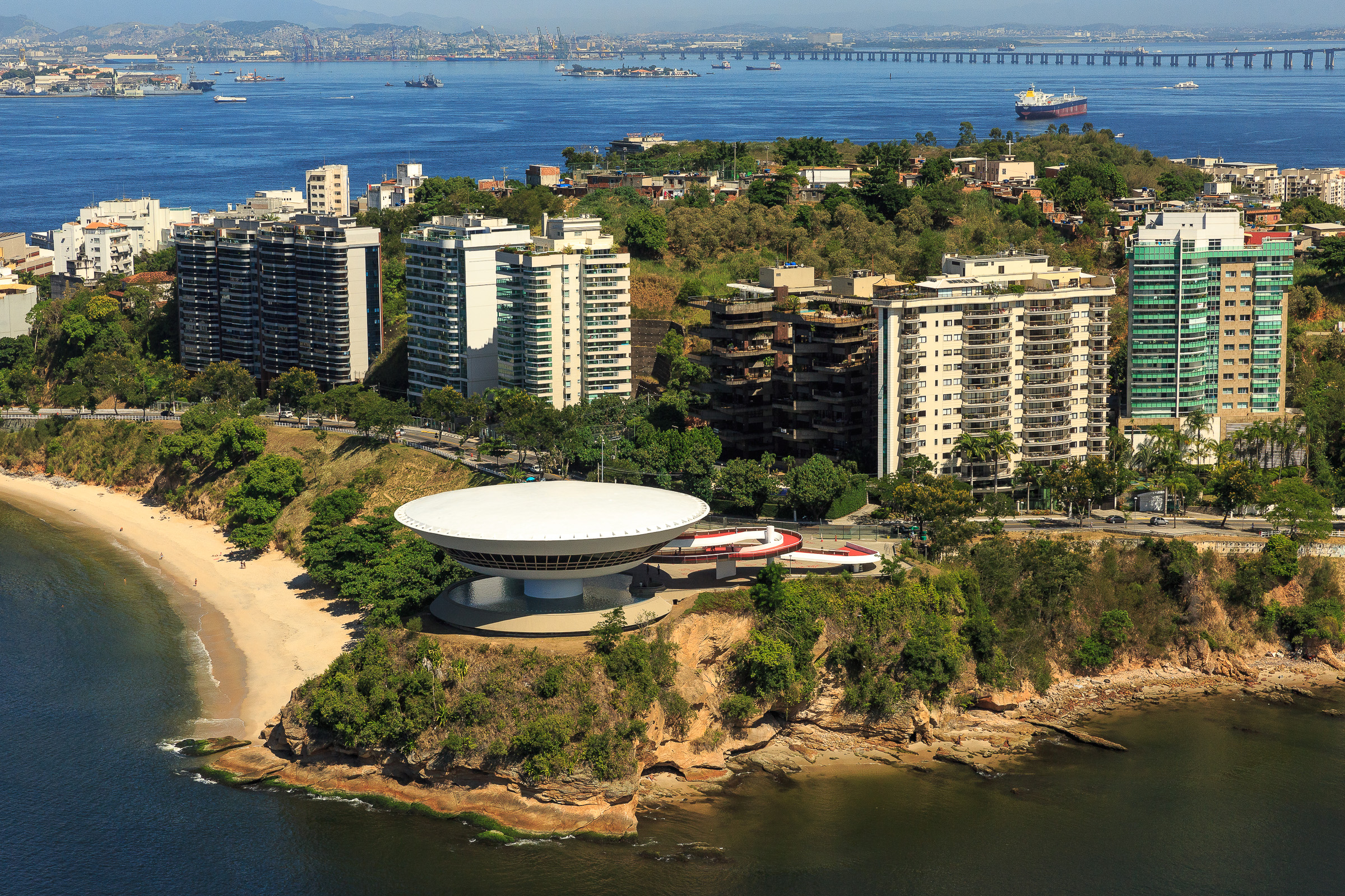
Niterói is a municipality in the state of Rio de Janeiro, in the southeast region of Brazil. It lies across Guanabara Bay, facing the city of Rio de Janeiro and forming part of the Rio de Janeiro Metropolitan Area. It was the capital of Rio de Janeiro, as marked by its golden mural crown, from 1834 to 1894 and again from 1903 to 1975. It has an estimated population of 515,317 inhabitants (2020) and an area of 129.375 km2 (49.952 sq mi), making it the fifth most populous city in the state. It has the highest Human Development Index in the state and the seventh highest among Brazil's municipalities in 2010. Individually, it is the municipality with the second highest average monthly household income per capita in Brazil and appears in 13th place among the municipalities of the country according to social indicators related to education. The city has the nicknames of Cidade Sorriso.
Adapted from Wikipedia, CC BY-SA 4.0.
Worth seeing in and around Niterói
10 places within 25 km that the world writes about, in the order of how widely: the ones a visitor has heard of first, then the ones only a local would name.
- 01Rio–Niterói Bridge
The Rio–Niterói Bridge, officially the President Costa e Silva Bridge, is a box girder bridge spanning the Guanabara Bay, connecting the cities of Rio de Janeiro and Niterói in the State of Rio de Janeiro, Brazil. It is currently the second longest bridge in Latin America, after the Metro Line 1 bridge, and the 48th longest in the world in 2020.
5.6 km · bridge in Rio de Janeiro · Wikipedia - 02National Library of Brazil
The National Library of Brazil is the depository of the bibliographic and documentary heritage of Brazil. It is located in Rio de Janeiro, the capital city of Brazil from 1763 to 1960, more specifically at Cinelândia square.
7.9 km · Brazilian national library · Wikipedia - 03Rio de Janeiro Cathedral
The Metropolitan Cathedral of Saint Sebastian, better known as the Metropolitan Cathedral of Rio de Janeiro or as the Cathedral of St. Sebastian of Rio de Janeiro, is a cathedral of the Catholic Church and the seat of the Archdiocese of Rio de Janeiro.
8.5 km · cathedral in Rio de Janeiro, Brazil · Wikipedia - 04Niterói Contemporary Art Museum
The Niterói Contemporary Art Museum is situated in the city of Niterói, Rio de Janeiro, Brazil, and is one of the city’s main landmarks. It was completed in 1996.
3.6 km · art museum · Wikipedia - 05Candelária Church
The Candelária Church is an important historical Roman Catholic church in the city of Rio de Janeiro, in southeastern Brazil. It was built and decorated during a long period, from 1775 to the late 19th century.
7.9 km · church in Rio de Janeiro · Wikipedia - 06Museu Nacional de Belas Artes
The Museu Nacional de Belas Artes is a national art museum located in the city of Rio de Janeiro, Brazil. The museum, officially established in 1937 by the initiative of education minister Gustavo Capanema, was inaugurated in 1938 by President Getúlio Vargas.
7.9 km · national art museum in the city of Rio de Janeiro, Brazil · Wikipedia - 07Teatro Municipal
The Theatro Municipal is an opera house in the Centro district of Rio de Janeiro, Brazil. Built in the early twentieth century, it is considered to be one of the most beautiful and important theaters in the country.
8 km · theater in Rio de Janeiro, Brazil · Wikipedia - 08National Historical Museum
The National Historical Museum of Brazil was created in 1922, and possesses over 287,000 items, including the largest numismatic collection of Latin America. The architectural complex that houses the museum was built in 1603 as the St.
7.2 km · history museum in Rio de Janeiro, Brazil · Wikipedia - 09Carioca Aqueduct
The Carioca Aqueduct, also known as Arcos da Lapa, is an aqueduct in the city of Rio de Janeiro, Brazil. The aqueduct was built in the middle of the 18th century to bring fresh water from the Carioca River to the population of the city.
8.5 km · 18th-century Aqueduct in Rio · Wikipedia - 10Museum of Tomorrow
The Museum of Tomorrow is a science museum in the city of Rio de Janeiro, Brazil. It was designed by Spanish neofuturistic architect Santiago Calatrava, and built next to the waterfront at Pier Maua.
7.9 km · science museum · Wikipedia
Ranked by the number of language editions of Wikipedia with an article on each, from Wikidata; the sentences are the openings of those articles, CC BY-SA 4.0.
What Wikivoyage says to see
- 01Niterói Contemporary Art Museum
- 02Parque da Cidade
An amazing view of Rio de Janeiro (city).
- 03Fortaleza de Santa Cruz
From Wikivoyage: Niterói, CC BY-SA 4.0. Not yet checked by us.
Things to do
Shopping - Icaraí is where the upper middle class lives. So there are plenty of nice shops for all tastes. "Paulo Gustavo" (1st street parallel to the beach) is the most popular shopping street in town. Here you will find exclusive and expensive boutiques such as Animale, Agilita, H.Stern, Salinas (beachware) all the way down to little t-shirt shops.
From Wikivoyage: Niterói, CC BY-SA 4.0. Not yet checked by us.
Where to eat
All restaurants are reasonably priced by American and European standards. A Mineira, Av. Quintino Bocaiuva, 353 (at the end of São Francisco Beach). Open flame regional cuisine of Minas State in a cozy chalet style restaurant. Large portions. Caneco gelado do Mário - Very rustic fish restaurant in the center of the city. Recommended by all of the travel guides as a restaurant not to be missed. Open only for lunch.
- 01Seu Antônio
Heleno de Gregório, 312 - Cafubá (from São Francisco beach, take the Charitas-Cafubá tunnel, turn first left after roundabout, turn first right at Rua Ver.
From Wikivoyage: Niterói, CC BY-SA 4.0. Not yet checked by us.
Getting to Niterói
- Airports
- Santos Dumont (SDU), 7 km · Rio de Janeiro Galeão – Tom Jobim (GIG), 17 km
- Stations
- Santos Dumont Airport, 6.7 km · Central do Brasil, 9.3 km · Port of Rio de Janeiro, 6.7 km · Flamengo, 9.7 km · Largo do Machado, 9.3 km
- São Paulo → Niterói368 km · quickest by air, 4h 31m · R$340–520
- Belo Horizonte → Niterói341 km · quickest by air, 5h 3m · R$350–540
- Vitória → Niterói404 km · quickest by air, 4h 7m · R$310–490
- Plan a tripFrom anywhereThe planner compares every way there from wherever you are.
Road and air are today’s quick answer; timetabled trains, buses and ferries load on the results page from the operators’ feeds.
No local-transport research exists yet for Niterói
Our researched notes are written from a sourced entry: every shared taxi, boat and village bus with its operator, its rule, its fare and the year we saw it, and what could not be confirmed. Nobody has done that work for Niterói. What is above is what we hold from open sources; nothing here pretends to be more.
- Get inFrom the center of the state capital, it is possible to go to Niterói by urban bus, van and ferry lines.
- Get inThe ferries depart from Praça XV station.
- Get inThe ferry between Rio and Niteroi is a pleasant and affordable trip.
- Get aroundTo get to the Oceanic Area you'd better have a car, otherwise take a municipal bus at the Bus Terminal next to the Ferry Station.
From Wikivoyage: Niterói, CC BY-SA. Not yet checked by us; that article was last edited 2026-09.
- 01113 km
- 021,145 km
- 032,464 km
- 042,568 km
- 052,737 km
If you know how people move in Niterói – the stand, the rule, the fare – tell us, and the note gets an entry.
Next door to Niterói
Niterói is 8 km from Rio de Janeiro, the nearest large city, whose note carries the wider picture.
- São Gonçalomunicipality of Rio de Janeiro state, Brazil8.1 km
- Flamengo Districtneighborhood of Rio de Janeiro9.2 km
- Urcaneighborhood of Rio de Janeiro9.7 km
- Santa Teresaneighborhood of Rio de Janeiro9.4 km
- Zona Central, Rio de Janeirohuman settlement7.9 km
- Escadaria Selarónarchitectural work in Rio de Janeiro city8.5 km