Maassluis
Maassluis is a town in the western Netherlands, in the province of South Holland.
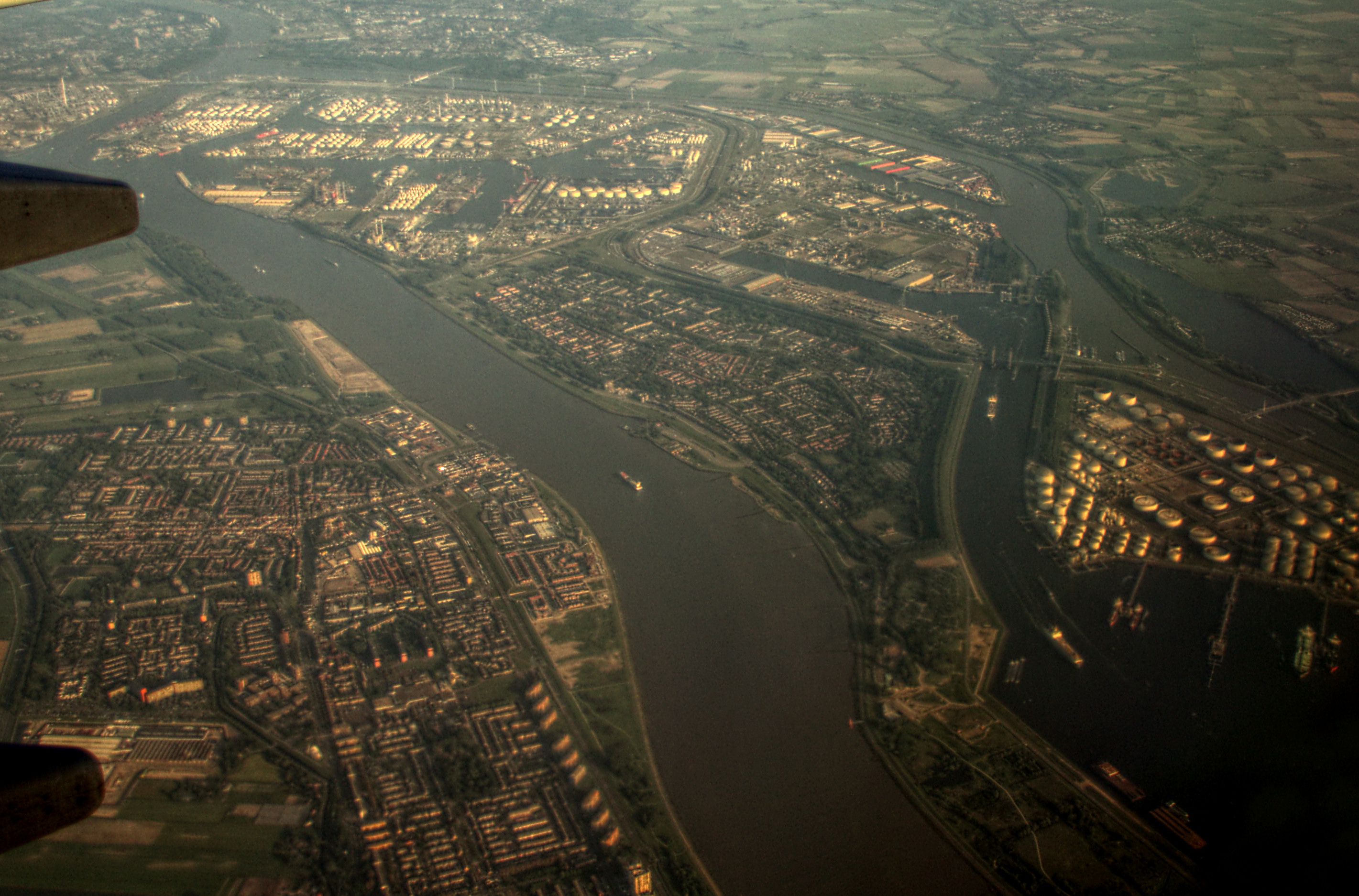
Maassluis is a town in the western Netherlands, in the province of South Holland. The municipality had a population of 33,567 in 2021 and covered 10.12 km2 (3.91 sq mi) of which 1.64 km2 (0.63 sq mi) was water.
Adapted from Wikipedia, CC BY-SA 4.0.
Worth seeing in and around Maassluis
4 places within 25 km that the world writes about, in the order of how widely: the ones a visitor has heard of first, then the ones only a local would name.
- 01Nieuwe Waterweg
The Nieuwe Waterweg is a ship canal in the Netherlands from het Scheur west of the town of Maassluis to the North Sea at Hook of Holland: the Maasmond, where the Nieuwe Waterweg connects to the Maasgeul. It is the artificial mouth of the river Rhine.
3 km · ship canal in the Netherlands · Wikipedia - 02Brielse meer
The Brielse Meer is a long, narrow lake between the Dutch estuary islands of Voorne and Rozenburg in the province of South Holland. The lake takes its name from Den Briel, a town on its shore.
4.3 km · lake in the Netherlands · Wikipedia - 03Calandbrug
The Calandbrug is a road and former railroad bridge over the Caland Canal in the port of Rotterdam in the Dutch municipality of Rotterdam. It is located west of Rozenburg at the end of the canal, which flows into the Brittanniëhaven here.
3.6 km · bridge in Rotterdam, Netherlands · Wikipedia - 04Historisch Museum Den Briel
The Historisch Museum Den Briel is a Dutch museum located in Brielle. The museum was previously known as the Trompmuseum, after Brielle-born Maarten Tromp who defeated the Spanish fleet in the Eighty Years' War.
5.8 km · museum in Brielle, the Netherlands · Wikipedia
Ranked by the number of language editions of Wikipedia with an article on each, from Wikidata; the sentences are the openings of those articles, CC BY-SA 4.0.
What Wikivoyage says to see
- 01Nationaal Sleepvaartmuseum
- 02Museum Maassluis
Zuiddijk 16,.
- 03Gemaal Mr
Zaayer Pumping Station), Vlaardingsedijk 10.
- 04Groote Kerk
Kerkplein 2,.
From Wikivoyage: Maassluis, CC BY-SA 4.0. Not yet checked by us.
Things to do
- 01Fair Play Casino
Nieuwe Weg 2, Rozenburg (beside the ferry across the Nieuwe Waterweg on the Rozenburg side),.
From Wikivoyage: Maassluis, CC BY-SA 4.0. Not yet checked by us.
Where to eat
Restaurants abound in the central section of the city. Try De Zoete Inval (Tea Room) on Dr Kuyperkade 15. Nice scones, coffee and tea.
From Wikivoyage: Maassluis, CC BY-SA 4.0. Not yet checked by us.
Getting to Maassluis
- Airports
- Rotterdam The Hague (RTM), 14 km · Amsterdam Schiphol (AMS), 55 km · Eindhoven (EIN), 95 km
- Stations
- Steendijkpolder, 500 m · Gunvor Energy Rotterdam, 4.5 km
- Amsterdam → Maassluis66 km · quickest by road, 1h 42m · €8–11
- Eindhoven → Maassluis100 km · quickest by road, 2h 31m · €13–18
- Maastricht → Maassluis156 km · quickest by road, 3h 22m · €22–31
- Plan a tripFrom anywhereThe planner compares every way there from wherever you are.
Road and air are today’s quick answer; timetabled trains, buses and ferries load on the results page from the operators’ feeds.
No local-transport research exists yet for Maassluis
Our researched notes are written from a sourced entry: every shared taxi, boat and village bus with its operator, its rule, its fare and the year we saw it, and what could not be confirmed. Nobody has done that work for Maassluis. What is above is what we hold from open sources; nothing here pretends to be more.
- Get inFrom here, head to the ferry connection south of the station.
- Get inThis ferry connects directly to Rozenburg.
- Get inThe nearest bus stop to the ferry is {{marker|type {{Station|Rozenburg, Grote Stern }}|lat 4.2443}}.
- Get inTweede Maasvlakte can be reached with the Hoeksveer Ferry which takes you from Hoek van Holland Haven to FutureLand in about 45 minutes.
- Get inThe ferry is suitable for pedestrians and bicycles only.
From Wikivoyage: Rotterdam/Port of Rotterdam, CC BY-SA. Not yet checked by us; that article was last edited 2026-09.
- 01157 km
- 02409 km
- 03621 km
- 04706 km
- 05717 km
If you know how people move in Maassluis – the stand, the rule, the fare – tell us, and the note gets an entry.
Next door to Maassluis
Maassluis is 17 km from The Hague, the nearest large city, whose note carries the wider picture.
- Briellehuman settlement in Voorne aan Zee, the Netherlands6 km
- Midden-Delflandmunicipality of the Netherlands5.6 km
- Rozenburgvillage and district of Rotterdam, Netherlands3.2 km
- De Liertown in South Holland, the Netherlands4.8 km
- Maasdijkfarm village in the Netherlands3.1 km
- Zwartewaalvillage in Voorne aan Zee, the Netherlands5.6 km