Caerphilly
Caerphilly is a town and community in Wales.
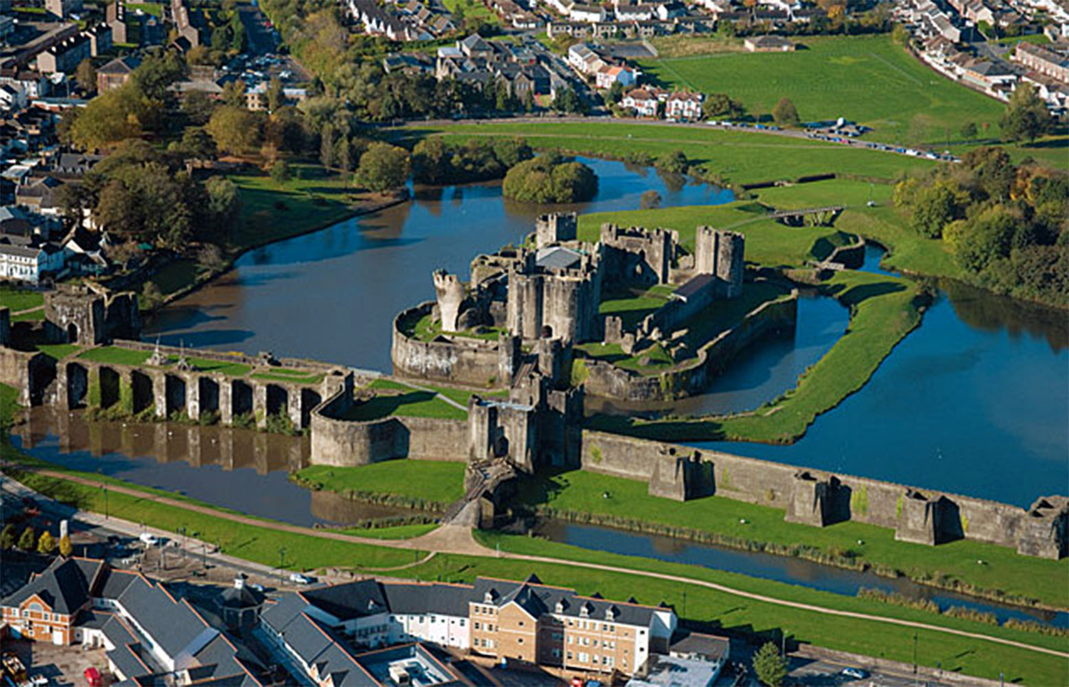
Caerphilly is a town and community in Wales. It is situated at the southern end of the Rhymney Valley and separated from the Cardiff suburbs of Lisvane and Rhiwbina by Caerphilly Mountain.
Adapted from Wikipedia, CC BY-SA 4.0.
Worth seeing in and around Caerphilly
10 places within 25 km that the world writes about, in the order of how widely: the ones a visitor has heard of first, then the ones only a local would name.
- 01Caerphilly Castle
Caerphilly Castle is a medieval fortification in Caerphilly in South Wales. The castle was constructed by Gilbert de Clare in the 13th century as part of his campaign to maintain control of Glamorgan, and saw extensive fighting between Gilbert, his descendants, and the native Welsh rulers.
300 m · castle in Caerphilly, Wales · Wikipedia - 02Castell Coch
Castell Coch is a 19th-century Gothic Revival castle built above the village of Tongwynlais in Wales. The first castle on the site was built by the Normans after 1081 to protect the newly conquered town of Cardiff and control the route along the River Taff.
5.3 km · castle in Tongwynlais, Cardiff, Wales · Wikipedia - 03Morgraig Castle
Morgraig Castle is a ruined castle, which lies close to the southern borders of the county borough of Caerphilly, overlooking Cardiff in Wales. It was built in the 13th century, but there is some debate as to who actually built the castle, either Gilbert de Clare or the Lord of Senghennydd.
2.9 km · castle in Caerphilly, Wales, UK · Wikipedia - 04Caerphilly mountain
Caerphilly Mountain lies between Cardiff and Caerphilly at the southern edge of the South Wales Coalfield. Its summit is 271 metres above sea-level.
1.8 km · mountain in United Kingdom · Wikipedia - 05Castell Coch Woodlands and Road Section
Castell Coch Woodlands and Road Section is a Site of Special Scientific Interest to the north of Cardiff, Wales, significant for both its biological and geological interest. The SSSI covers an area of 17 hectares around the Victorian gothic castle of Castell Coch, 5 miles, 8 km north-west of Cardiff.
5.3 km · Site of Special Scientific Interest in Cardiff, Wales, UK · Wikipedia - 06Thornhill Cemetery
Thornhill Cemetery and Cardiff Crematorium is a major cemetery and crematorium located in Thornhill, a northern suburb of Cardiff, south Wales. It is located on the A469 road.
4.6 km · cemetery in Cardiff, Wales · Wikipedia - 07Craig yr Allt
Craig yr Allt is a hill in South Wales, overlooking Caerphilly to the east and the villages of Nantgarw and Taff's Well to the west. The Taff Ely Ridgeway Walk passes over the hill.
3.2 km · hill (273m) in Rhondda Cynon Taf · Wikipedia - 08Fforestganol a Chwm Nofydd
Fforestganol a Chwm Nofydd is a Site of Special Scientific Interest north of the M4 motorway and east of Tongwynlais, in Cardiff, Wales.
4 km · Site of Special Scientific Interest in Wales · Wikipedia - 09Welsh National and Universal Mining Disaster Memorial Garden
The Welsh National and Universal Mining Disaster Memorial Garden at Senghenydd, Caerphilly, commemorates the 439 men killed in the Senghenydd colliery disaster of 1913, the worst mining accident in British history; the 81 lives lost in an earlier pit explosion at Senghenydd in 1901; and acts as a national memorial to all of the dead of the 152 mining disasters that have occurred in Wales. The garden was opened in 2013, the centenary of the 1913 event.
5.7 km · memorial garden in Caerphilly, Wales · Wikipedia - 10Walnut Tree Viaduct
Walnut Tree Viaduct was a railway viaduct located above the southern edge of the village of Taffs Well, South Wales. Originally built to carry the Barry Railway across a narrow gorge through which the River Taff, Taff Vale Railway and Cardiff Railway passed, it was deconstructed in 1969, leaving only two of the support columns visible from the A470 road.
5.4 km · bridge in United Kingdom · Wikipedia
Ranked by the number of language editions of Wikipedia with an article on each, from Wikidata; the sentences are the openings of those articles, CC BY-SA 4.0.
What Wikivoyage says to see
- 01Caerphilly Castle
Castle Street, CF83 1JD (in the town centre, you can't miss it),.
- 02Tommy Cooper
Just up the hill from Caerphilly Castle is the town's most famous son: just like that!
From Wikivoyage: Caerphilly, CC BY-SA 4.0. Not yet checked by us.
Things to do
The Big Cheese (Annual Arts Festival): 2. This festival takes place on the last weekend of July in the grounds of Caerphilly Castle, with music, comedy, cheese racing, and historical reenactments. Free event. (date needs fixing) Megaday:. Usually held in the grounds of Caerphilly Rugby Club, this is held the last weekend of August to raise money for nearby Velindre Hospital.
From Wikivoyage: Caerphilly, CC BY-SA 4.0. Not yet checked by us.
Where to eat
The hard, white Caerphilly Cheese, which was originally made in the surrounding countryside and sold at the market in the town. Production of the real farmhouse Caerphilly died out during World War II as milk production was diverted to the large cheddar factories, but the practice has been revived in recent times. Caerphilly Mountain snack bar, Mountain Rd, Caerphilly CF83 1JA, +44 29 2088-5050
From Wikivoyage: Caerphilly, CC BY-SA 4.0. Not yet checked by us.
Getting to Caerphilly
- Airports
- Cardiff (CWL), 22 km · Bristol (BRS), 41 km · Birmingham (BHX), 140 km
- Stations
- Taffs Well railway station, 5.2 km · Llanbradach railway station, 3 km · Llanishen railway station, 5.6 km · Lisvane and Thornhill railway station, 4.4 km · Caerphilly railway station, 700 m
- Bristol → Caerphilly45 km · quickest by road, 1h 31m · £6–8
- Birmingham, West Midlands → Caerphilly135 km · quickest by road, 2h 53m · £16–21
- London → Caerphilly214 km · quickest by road, 4h · £22–29
- Plan a tripFrom anywhereThe planner compares every way there from wherever you are.
Road and air are today’s quick answer; timetabled trains, buses and ferries load on the results page from the operators’ feeds.
No local-transport research exists yet for Caerphilly
Our researched notes are written from a sourced entry: every shared taxi, boat and village bus with its operator, its rule, its fare and the year we saw it, and what could not be confirmed. Nobody has done that work for Caerphilly. What is above is what we hold from open sources; nothing here pretends to be more.
- Go nextIt is possible to visit Hereford as a day trip, using either train or car.
From Wikivoyage: Cardiff, CC BY-SA. Not yet checked by us; that article was last edited 2026-09.
- 01110 km
- 02166 km
- 03462 km
- 04474 km
- 05498 km
If you know how people move in Caerphilly – the stand, the rule, the fare – tell us, and the note gets an entry.
Next door to Caerphilly
Caerphilly is 11 km from Cardiff, the nearest large city, whose note carries the wider picture.
- Rudryvillage and community located to the east of Caerphilly in Wales3.8 km
- Taff's Wellvillage and community in Rhondda Cynon Taf, Wales, UK5.1 km
- Llanishensuburb and community in Cardiff, Wales5.8 km
- Tongwynlaisdistrict of Cardiff, Wales5.7 km
- Lisvanedistrict and community of Cardiff, Wales5.1 km
- Vanvillage and community in Caerphilly, Wales, UK1.1 km