Brightholmlee
Brightholmlee is a small rural hamlet within the City of Sheffield in England.
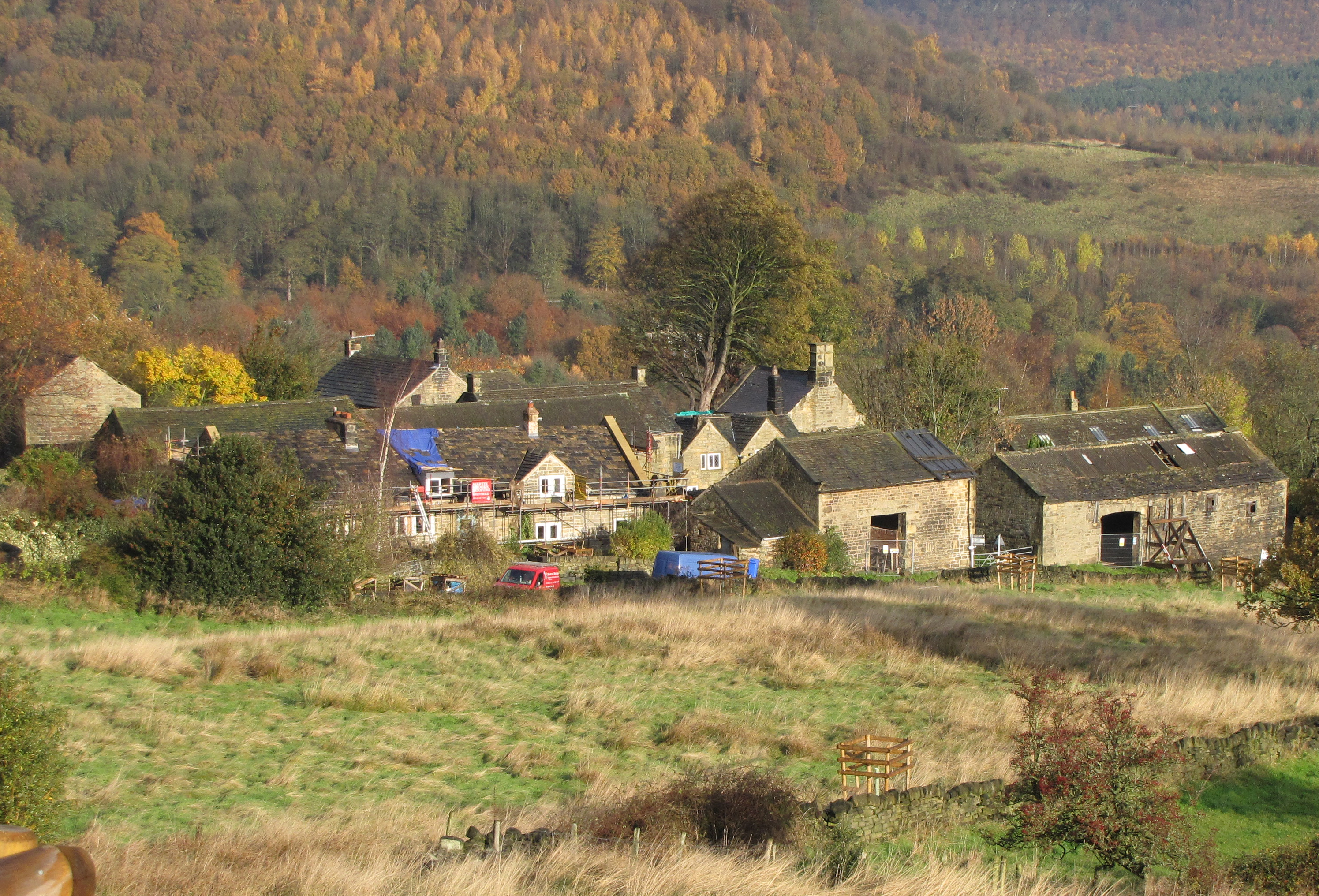
Brightholmlee is a small rural hamlet within the City of Sheffield in England. The hamlet falls within the Stannington Ward of the city. It is 6.2 miles (10 km) north-west of the city centre and 0.6 miles (1 km) west of Wharncliffe Side within Bradfield parish. Previously a farming community, it consists of four farmsteads, Manor Farm, Old Hall Farm, High Lea Farm and Lee Farm. It is now almost entirely residential with the last working farm being sold for development in 2013.
Adapted from Wikipedia, CC BY-SA 4.0.
Worth seeing in and around Brightholmlee
8 places within 25 km that the world writes about, in the order of how widely: the ones a visitor has heard of first, then the ones only a local would name.
- 01Church of St Nicholas
Bradfield Church is situated in the small village of High Bradfield, which is located 6 miles north west of the centre of the city of Sheffield in South Yorkshire, England. It is one of only five Grade One listed buildings in Sheffield.
3.5 km · Grade I listed church in High Bradfield, Sheffield, South Yorkshire, England, UK · Wikipedia - 02Stocksbridge Town Hall
Stocksbridge Town Hall is a municipal building in Manchester Road in Stocksbridge, a town in South Yorkshire in England. The town hall, which was previously the offices and meeting place of Stocksbridge Urban District Council, is now the home of Stocksbridge Town Council as well as other community organisations.
3.7 km · municipal building in England · Wikipedia - 03Glen Howe Park
Glen Howe Park is a public recreation area in the village of Wharncliffe Side within the City of Sheffield, England. The park covers an area of 19 acres in the valley of the Tinker Brook, a minor tributary of the River Don.
900 m · park in Wharncliffe Side, South Yorkshire, England · Wikipedia - 04Canyards Hills
Canyards Hills is a 64.1 hectare biological and geological site of Special Scientific Interest in South Yorkshire. The site was notified in 1990.
3.9 km · Site of Special Scientific Interest in South Yorkshire, England, UK · Wikipedia - 05Broomhead Reservoir
Broomhead Reservoir is a reservoir located in the Ewden Valley, near Sheffield in South Yorkshire, England. The reservoir is located to the south of Bolsterstone and is linked to the More Hall Reservoir to the east.
2.4 km · reservoir in South Yorkshire, UK · Wikipedia - 06More Hall Reservoir
More Hall Reservoir is a reservoir located in the Ewden valley near Sheffield, South Yorkshire, England. The reservoir is situated to the south of Bolsterstone and is linked to the Broomhead Reservoir to the west.
700 m · reservoir in South Yorkshire, England, UK · Wikipedia - 07Onesacre Hall
Onesacre Hall is a Grade II* Listed building situated in the rural outskirts of the City of Sheffield in South Yorkshire, England. The hall is located on Green Lane in the small hamlet of Onesacre in the suburb of Oughtibridge, 5 miles north west of the city centre.
1.8 km · house in Bradfield, Sheffield, England, UK · Wikipedia - 08St Mary's Church, Bolsterstone
St Mary's Church, Bolsterstone is situated in the village of Bolsterstone, within the boundary of the City of Sheffield in South Yorkshire, England. The church dates from 1879 although there is evidence that a place of worship has existed on the site since the 12th century.
2.6 km · grade II listed church in Bolsterstone, Sheffield, South Yorkshire, England, UK · Wikipedia
Ranked by the number of language editions of Wikipedia with an article on each, from Wikidata; the sentences are the openings of those articles, CC BY-SA 4.0.
Getting to Brightholmlee
- Airports
- Leeds Bradford (LBA), 46 km · Manchester (MAN), 49 km · East Midlands (EMA), 71 km
- Leeds, West Yorkshire → Brightholmlee38 km · quickest by road, 58 min · £4.5–6
- Manchester, Greater Manchester → Brightholmlee45 km · quickest by road, 1h 31m · £5–7
- Nottingham, Leicestershire → Brightholmlee62 km · quickest by road, 1h 37m · £8–10
- Plan a tripFrom anywhereThe planner compares every way there from wherever you are.
Road and air are today’s quick answer; timetabled trains, buses and ferries load on the results page from the operators’ feeds.
No local-transport research exists yet for Brightholmlee
Our researched notes are written from a sourced entry: every shared taxi, boat and village bus with its operator, its rule, its fare and the year we saw it, and what could not be confirmed. Nobody has done that work for Brightholmlee. What is above is what we hold from open sources; nothing here pretends to be more.
- Go nextFor a day trip by public transport, the most accessible is along the Hope Valley railway line through Grindleford, Hathersage, Hope and Edale.
From Wikivoyage: Sheffield, CC BY-SA. Not yet checked by us; that article was last edited 2026-09.
- 01308 km
- 02329 km
- 03330 km
- 04365 km
- 05392 km
If you know how people move in Brightholmlee – the stand, the rule, the fare – tell us, and the note gets an entry.
Next door to Brightholmlee
Brightholmlee is 10 km from Sheffield, the nearest large city, whose note carries the wider picture.
- Stocksbridgetown in the City of Sheffield, South Yorkshire, England3.3 km
- Wortleyvillage and civil parish in South Yorkshire, England, UK4 km
- Oughtibridgevillage in South Yorkshire, UK2.4 km
- Bradfieldcivil parish in the City of Sheffield, in South Yorkshire, England3.4 km
- Worrallvillage in Sheffield, South Yorkshire, United Kingdom3.5 km
- Deepcarvillage in South Yorkshire, England, UK2.5 km