Borley
Borley is a village and civil parish in rural north Essex, England.
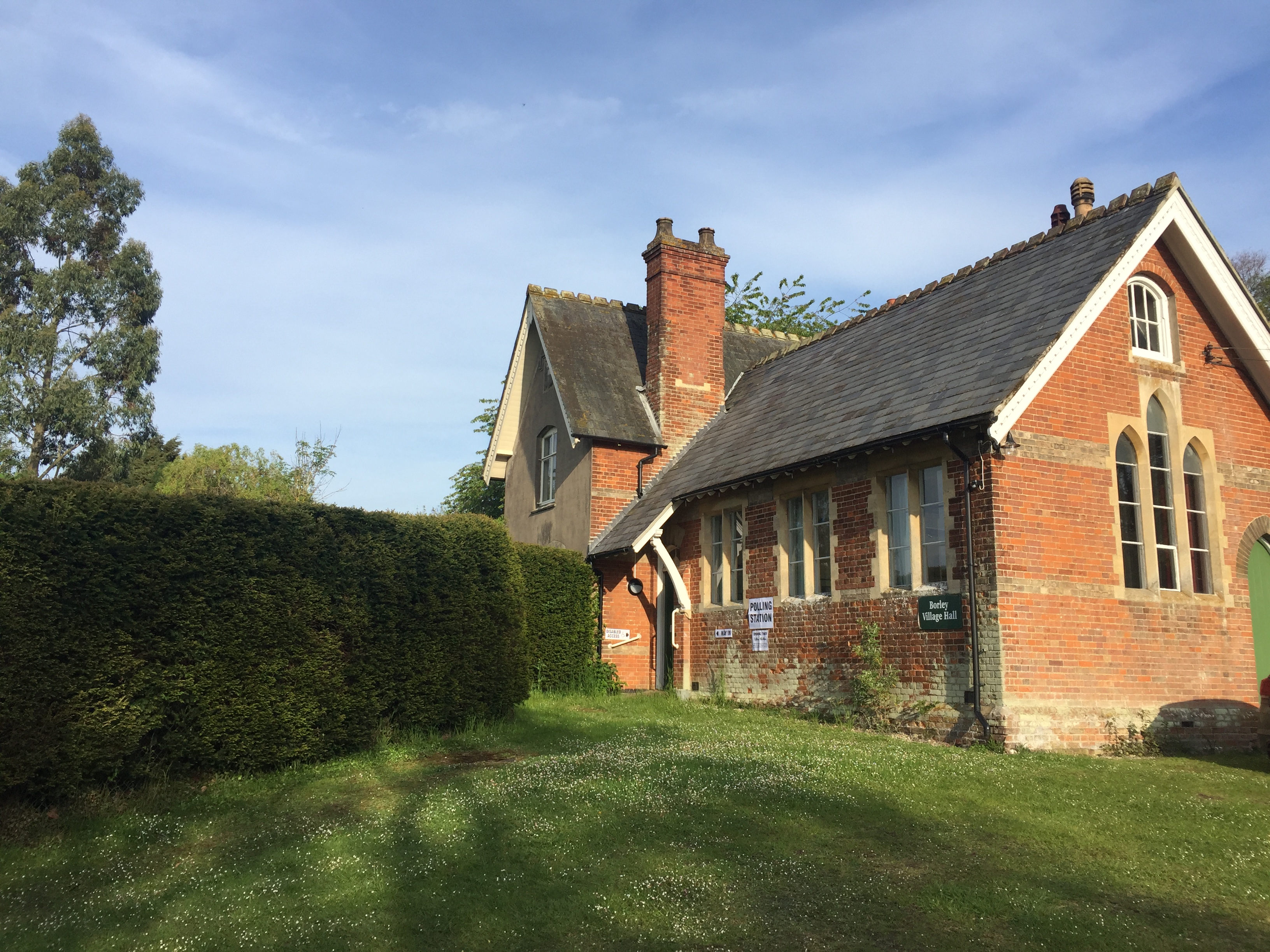
Borley is a village and civil parish in rural north Essex, England. It lies close to the border with Suffolk and near the River Stour. The closest town is Sudbury, Suffolk,
approximately 3 km (1.9 mi) southeast of Borley; Sudbury is also the Post Town used by Royal Mail for Borley. The neighbouring parishes are Foxearth, Belchamp Walter and Bulmer. At the 2021 census the parish had a population of 111.
Adapted from Wikipedia, CC BY-SA 4.0.
Worth seeing in and around Borley
9 places within 25 km that the world writes about, in the order of how widely: the ones a visitor has heard of first, then the ones only a local would name.
- 01Borley Rectory
Borley Rectory was a house located in Borley, Essex, famous for being described as "the most haunted house in England" by psychic researcher Harry Price. Built in 1862 to house the rector of the parish of Borley and his family, the house was badly damaged by fire in 1939 and demolished in 1944.
300 m · building in Borley, Essex, England · Wikipedia - 02Holy Trinity Church, Long Melford
The Church of the Holy Trinity is a Grade I listed parish church of the Church of England in Long Melford, Suffolk, England. It is one of 310 medieval English churches dedicated to the Holy Trinity.
3.9 km · church in Long Melford, Suffolk, England, UK · Wikipedia - 03Gainsborough's House
Gainsborough's House is the birthplace of the leading English painter Thomas Gainsborough. It is now a museum and gallery, located at 46 Gainsborough Street in Sudbury, Suffolk, England.
2.9 km · museum in Sudbury, United Kingdom, birthplace of the leading English painter Thomas Gainsborough · Wikipedia - 04Melford Hall
Melford Hall is a stately home in the village of Long Melford, Suffolk, England. Since 1786 it has been the seat of the Parker Baronets and is still lived in by the Hyde Parker family.
3.4 km · Grade I listed house in Long Melford, Suffolk, England, UK · Wikipedia - 05Church of St Gregory, Sudbury
The Church of St Gregory, Sudbury is a Church of England parish church, located in the town of Sudbury in Suffolk, England. First mentioned in the 10th century, most of the present building dates from the 14th and 15th centuries.
2.6 km · church in Sudbury, Suffolk, England, UK · Wikipedia - 06Belchamp Hall
Belchamp Hall is a Queen Anne-style country house in the parish of Belchamp Walter, Essex, near Sudbury, Suffolk, England. It is a privately owned Grade II* listed building.
3.4 km · country house in Belchamp Walter, Essex, England, UK · Wikipedia - 07Glemsford Pits
Glemsford Pits is a 37.5-hectare biological Site of Special Scientific Interest south of Glemsford in Suffolk. The River Stour, which forms the boundary between Suffolk and Essex, runs through the site, which is thus in both counties.
3.2 km · biological Site of Special Scientific Interest in England · Wikipedia - 08Town Hall
Sudbury Town Hall is a municipal building in Gaol Lane in Sudbury, Suffolk, England. The building, which was the headquarters of Sudbury Borough Council, is a Grade II listed building.
3 km · town hall in Sudbury, Babergh, Suffolk, England, UK · Wikipedia - 09St Peter's Church, Sudbury
St Peter's Church, Sudbury is a former Anglican church in the town of Sudbury, Suffolk, England, which now serves as an Arts Centre. The building is recorded in the National Heritage List for England as a designated Grade I listed building, and is under the care of the Churches Conservation Trust.
3 km · church in Sudbury, Suffolk, England, UK · Wikipedia
Ranked by the number of language editions of Wikipedia with an article on each, from Wikidata; the sentences are the openings of those articles, CC BY-SA 4.0.
Getting to Borley
- Airports
- London Stansted (STN), 37 km · London Luton (LTN), 76 km · London Heathrow (LHR), 103 km
- Stations
- Sudbury railway station, 3.4 km · Long Melford railway station, 1.5 km · Glemsford railway station, 3.8 km
- Luton, Luton → Borley78 km · quickest by road, 2h 12m · £9–12
- London → Borley83 km · quickest by road, 2h 24m · £10–13
- Nottingham, Leicestershire → Borley160 km · quickest by road, 3h 19m · £18–24
- Plan a tripFrom anywhereThe planner compares every way there from wherever you are.
Road and air are today’s quick answer; timetabled trains, buses and ferries load on the results page from the operators’ feeds.
No local-transport research exists yet for Borley
Our researched notes are written from a sourced entry: every shared taxi, boat and village bus with its operator, its rule, its fare and the year we saw it, and what could not be confirmed. Nobody has done that work for Borley. What is above is what we hold from open sources; nothing here pretends to be more.
- Get inThe complete route requires ferry crossings, and follows a mix of on- and off-road paths and terrains.
From Wikivoyage: Long Melford, CC BY-SA. Not yet checked by us; that article was last edited 2026-09.
- 01206 km
- 02319 km
- 03383 km
- 04547 km
- 05582 km
If you know how people move in Borley – the stand, the rule, the fare – tell us, and the note gets an entry.
Next door to Borley
- Sudburytown in Babergh, Suffolk, England2.7 km
- Long Melfordvillage and civil parish in Babergh, Suffolk, England2.7 km
- Foxearthvillage in Essex, England, UK2.4 km
- Listonvillage and civil parish in Essex, United Kingdom1.6 km
- Bulmervillage and civil parish in Essex, UK3.1 km
- Chiltonvillage and civil parish in Suffolk, United Kingdom4 km