Obalende
Obálendé, a contraction of the Yoruba saying Ibi ti Oba le wa de, meaning "Where the king chased us to", is a neighbourhood of Lagos, Nigeria, located in Eti-Osa LGA, close to Lagos Island.
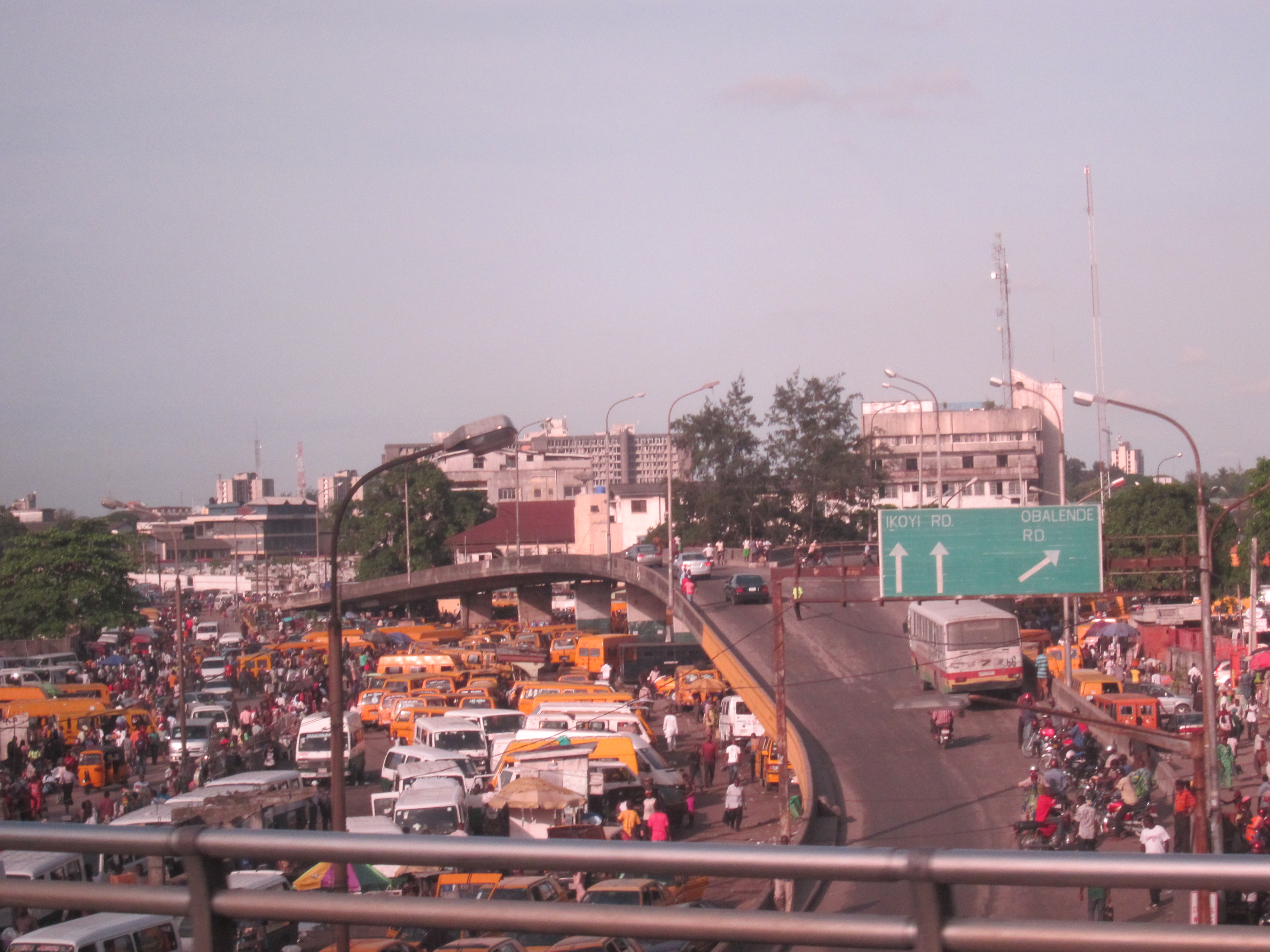
Obálendé, a contraction of the Yoruba saying Ibi ti Oba le wa de, meaning "Where the king chased us to", is a neighbourhood of Lagos, Nigeria, located in Eti-Osa LGA, close to Lagos Island. Eti-Osa was split by the Lagos State Government into Local Community Development Areas (LCDA) of which Ikoyi–Obalende is one. It contains many schools, including Holy Child College Obalende, St Gregory's College, Aunty Ayo International School and Girls Secondary Grammar School. It is bordered by the police barracks and Army barracks. Obalende is extremely crowded and congested. Obalende is famous for its night life, its red-light district and for its suya with a junction popularly called Suya junction.
Adapted from Wikipedia, CC BY-SA 4.0.
Worth seeing in and around Obalende
10 places within 25 km that the world writes about, in the order of how widely: the ones a visitor has heard of first, then the ones only a local would name.
- 01Nigerian National Museum, Lagos
The Nigerian National Museum is a national museum of Nigeria, located in the city of Lagos. The museum has a notable collection of Nigerian art, including pieces of statuary, carvings, and archaeological and ethnographic exhibits.
1.6 km · national museum in Nigeria · Wikipedia - 02Onikan Stadium
The Mobolaji Johnson Arena, previously known as Onikan Stadium, is a multi-purpose stadium in Lagos, Nigeria. It is currently used for football matches and is the home stadium of 1472 F.C, First Bank F.C, Ikorodu City F.C, Inter Lagos, Julius Berger F.C, Prince Kazeem Eleku F.C, Smart City F.C, Sporting Lagos, Stationery Stores F.C. and Valiant F.C. The Mobolaji Johnson Arena has a capacity of 10,000 people and is the oldest in Nigeria.
1.7 km · stadium · Wikipedia - 03Cathedral Church of Christ, Lagos
The Cathedral Church of Christ Marina, Lagos is an Anglican cathedral on Lagos Island, Lagos, Nigeria.
3.1 km · a church building in Nigeria · Wikipedia - 04Cathedral of the Holy Cross, Lagos
Holy Cross Cathedral is a Roman Catholic cathedral located in Lagos, Nigeria, and is the seat of the Archdiocese of Lagos. The Gothic style building was constructed in 1939, when the region was still administered as an apostolic vicariate, and thus was only elevated to the status of cathedral in 1950.
2.4 km · cathedral in Lagos, Nigeria · Wikipedia - 05Eko Bridge
Eko Bridge is one of three bridges connecting Lagos Island to the mainland, the others being the Third Mainland and Carter bridges. The bridge was built in 1975 and is the shortest of the three bridges linking Lagos Island to mainland.
4.6 km · bridge in Nigeria · Wikipedia - 06Balogun Market
Balogun Ajeniya Market is a market located on Lagos Island in Lagos State, Nigeria. The market has no particular address because it sprawls across so many streets on the island.
3.8 km · market in Nigeria · Wikipedia - 07Shitta-Bey Mosque
Shitta-Bey Mosque is a mosque, religious learning centre and one of the oldest mosques in Southern Nigeria and the first internationally recognised mosque in Nigeria. The mosque is located at Martins Ereko Street, Lagos Island, Lagos, Nigeria.
3.7 km · building in Africa · Wikipedia - 08Lagos Central Mosque
The Lagos Central Mosque is a jum'at mosque, located in Lagos Island, Lagos, the largest city in Nigeria. The mosque serves as the principal home of the Chief Imam of Lagos.
3.5 km · mosque in Lagos, Nigeria · Wikipedia - 09Freedom Park
Freedom Park is a memorial and leisure park area in the middle of downtown Lagos in Lagos Island, Nigeria which was formerly Her Majesty's Broad Street Prison. It was designed by the architect Theo Lawson as a speculative project under the CIA-Lagos in 1999.
2.4 km · park in Nigeria · Wikipedia - 10360 Degrees Tower collapse
On 1 November 2021, a high-rise block of luxury flats under construction in the neighbourhood of Ikoyi in Lagos, Nigeria, collapsed. At least 42 people died.
3.2 km · building collapse in Ikoyi, Lagos, Nigeria · Wikipedia
Ranked by the number of language editions of Wikipedia with an article on each, from Wikidata; the sentences are the openings of those articles, CC BY-SA 4.0.
Getting to Obalende
- Airports
- Murtala Muhammed (LOS), 18 km · Cotonou Cadjehoun (COO), 115 km · Lomé–Tokoin (LFW), 241 km
- Stations
- Apapa Port Complex, 2.8 km · Lagos Terminus Railway Station, 4.8 km
- Ilorin/Ogbomosho → Obalende253 km · quickest by road, 4h 11m · ₦16,150–21,500
- Asaba → Obalende368 km · quickest by air, 4h 34m · ₦87,820–136,250
- Port Harcourt → Obalende439 km · quickest by air, 5h 39m · ₦107,240–166,350
- Plan a tripFrom anywhereThe planner compares every way there from wherever you are.
Road and air are today’s quick answer; timetabled trains, buses and ferries load on the results page from the operators’ feeds.
No local-transport research exists yet for Obalende
Our researched notes are written from a sourced entry: every shared taxi, boat and village bus with its operator, its rule, its fare and the year we saw it, and what could not be confirmed. Nobody has done that work for Obalende. What is above is what we hold from open sources; nothing here pretends to be more.
- Get aroundAvoid taking an Okada for long distances, while it's raining and in the night Okadas and kekes (tuk tuks) were banned by the government in Lagos/Victoria Islands, Ikeja, Apapa, Yaba, and certain other Mainland districts of Lagos effective Feb of 2020 for safety reasons.
- Get aroundAvis is your best bet for this; either call or make use of their online services: Lagos Ferry Services Company runs scheduled routes between Lagos Island, Banana island, Mile 2 (Apapa axis) and the mainland.
- Get aroundModern ferries have been assigned to carry both passengers and cargo on the lagoon and on some creeks.
From Wikivoyage: Lagos City, CC BY-SA. Not yet checked by us; that article was last edited 2026-08.
- 01696 km
- 022,849 km
- 033,036 km
- 043,290 km
- 053,300 km
If you know how people move in Obalende – the stand, the rule, the fare – tell us, and the note gets an entry.
Next door to Obalende
Obalende is 3 km from Lagos, the nearest large city, whose note carries the wider picture.
- Eko Atlanticcity in Lagos State, Nigeria5.2 km
- Ikoyineighbourhood of Lagos, Nigeria, located in Eti-Osa Local Government Area2.2 km
- Oto-Aworilocal Council Development Area and town in Lagos State, Nigeria400 m
- Maroko, Lagos Statecommunity in Eti-Osa, Lagos State, Nigeria4.5 km